Why Curbs Are More Than the Edge of the Road
Learn how to read a curb along a city block, spot who it serves, and understand how its shape and markings organize everyday street use.
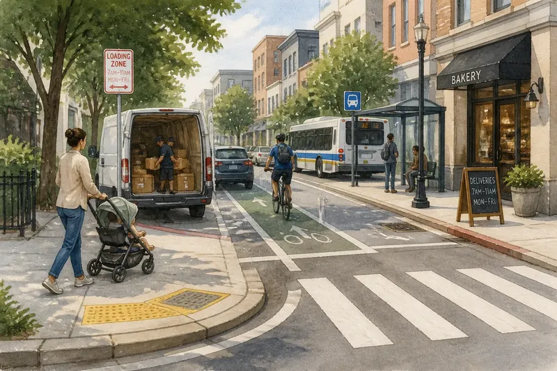
At the corner store, a delivery van pauses beside the curb while a parent steers a stroller around its rear and a cyclist slips past in the street. That narrow strip of concrete is doing more than marking where the road ends. To read a curb along a city block, look at its shape, its openings, its markings, and the people and vehicles using the space.
A curb can separate moving traffic from a sidewalk, offer a place to board a bus, protect a bike lane, or give a driver room to load a package. It can also connect these uses by creating a point where people cross, park, wait, or transfer from one mode of travel to another. Read the block in sequence rather than treating every curb as the same boundary.
Where does the curb change the street?
Start at one end of a block and walk on the sidewalk, keeping a comfortable distance from traffic. Notice where the curb begins, where it bends, and where it disappears into a driveway or crossing. A sudden change often signals that the street is making room for a different activity.
At a corner, the curb usually turns around a curb ramp or a raised corner. Along a storefront, it may run straight beside a parking lane. Near a driveway, the sidewalk may slope across the access point, even as the curb line dips. These changes are clues, not a complete explanation: the same shape can serve different purposes on different streets.
For a simple first pass, note three things as you go:
- Shape: Is the curb tall and continuous, lowered, rounded, or interrupted?
- Surface: Is there a painted lane, a textured warning surface, a drain opening, or a loading sign nearby?
- Use: Are people walking, waiting, cycling, parking, boarding, or moving goods there?
Then ask where the curb helps one use meet another. A lowered section at a crosswalk connects the sidewalk to the street crossing. A bus stop connects the sidewalk to a vehicle door. A curbside loading space connects a shop to deliveries while competing with other possible uses of the same edge.
What can the curb’s shape tell you?
A raised curb creates a noticeable boundary between sidewalk and roadway. It helps make the walking area legible and can discourage vehicles from drifting onto it. The boundary is not absolute: driveways, curb ramps, and intersections create deliberate openings.
A curb ramp lowers the route between sidewalk and street. Look for a sloped surface and, at many crossings, a panel with raised bumps near the street edge. That textured panel is a warning surface for people with limited or no vision. The ramp’s direction matters too: it may point toward the crosswalk, or it may sit at an angle that asks people to turn before crossing.
Where a curb bends outward into the roadway, the extension may shorten the crossing or make more sidewalk space available at a corner. It can also make the corner easier to see from a vehicle. A rounded or lowered curb at a driveway, by contrast, gives vehicles a place to cross the sidewalk. Watch how pedestrians move through that point: a driveway remains part of the walking route, even when cars have access across it.
Some streets have a buffer between the curb and moving traffic. It might be a planted strip, a row of parking spaces, or a raised bike lane. The curb then helps define the outer edge of one area, while another feature separates the next. Read the whole arrangement rather than assigning every job to the concrete alone.
Who is using the curbside space?
Pause briefly at each distinct section and notice what the space supports. A parked car suggests storage, but a sign may reserve the curb for deliveries at certain times. A bus stop sign, shelter, or boarding island suggests passenger access. A painted bicycle symbol may indicate a bike lane, while a raised edge or row of posts can provide additional separation.
Look for clues that reveal a use even when nobody is there. A marked accessible parking space, a hydrant, a bus stop pole, a loading zone sign, or a cut-through for a driveway can all shape what is allowed or possible. Signs and curb paint may change along a block, so check the whole stretch rather than carrying one interpretation from one end to the other.
Imagine you are reading a block with a bakery, a bus stop, and a marked bike lane. You first notice that the bike lane runs beside parked cars, then ends near the bus stop, where people board from the curb. At the bakery, a sign reserves a short section for deliveries during posted hours. The observable result of this walk is a clearer map of how cycling, boarding, and deliveries are assigned space—and where those uses meet.
Keep your observations descriptive. “The curbside area is used for boarding here” is more useful than assuming why a design decision was made. A sign, painted marking, or physical barrier offers evidence about present use; it may not explain the history or the full rule behind it.
How do curb openings and markings change the route?
Follow the walking surface as carefully as the curb line. A curb ramp may lead to a marked crosswalk, an unmarked crossing, or a driveway. These are different connections, even if they look close together. Notice whether the ramp aligns with the place people are expected to cross and whether there is a clear path from it to the opposite sidewalk.
At a transit stop, look for the relationship between the waiting area and the vehicle’s boarding point. A bus may pull alongside the curb, stop in a traffic lane, or use a boarding island. The curb can help separate waiting passengers from traffic, but poles, benches, signs, or parked vehicles may affect how people reach the stop.
At a driveway or alley, the sidewalk often continues across a lowered section. The visible opening allows vehicles to cross, but pedestrians still need a usable path. Watch for the direction of the slope, the continuity of the walking surface, and whether a person using a mobility device would need to enter the roadway to get around an obstruction.
These details matter because a curb is both a boundary and a seam. It divides areas with different users, yet it is also where people shift from walking to boarding, crossing, or reaching a building. A continuous curb can make the sidewalk easy to follow; a well-placed opening can make a necessary connection possible.
How should you record what you see?
If you want to compare two blocks or explain a confusing corner, make a quick field note. Write the street name and the direction you walked. Sketch the curb line with simple marks for ramps, driveways, signs, stops, and interruptions. Add brief labels such as “bus boarding,” “loading sign,” or “bike lane ends.”
A phone note or a simple map app can help, but keep your attention on the walking route and surrounding traffic. Do not stop in a bike lane, driveway, or at the edge of a crossing to take a photo. If you take a picture, do so from a safe place on the sidewalk and avoid capturing identifiable people where possible.
Separate what you observed from what you infer. “Curb lowered at driveway; sidewalk slopes across opening” describes visible features. “This may be a vehicle entrance” is an interpretation. That distinction makes your notes more useful to neighbors, local staff, or a transportation agency if you later choose to report an access concern.
What questions help you read a curb?
How can I tell whether a curbside space is for parking or loading?
Look for posted signs, painted curb markings, and nearby restrictions rather than relying on the presence of a parked vehicle. Rules can vary by block and time of day, so read the local signs before stopping or parking there.
What does a curb ramp connect?
It connects a sidewalk or corner to the street level, often at a crossing or driveway. Check where its slope points and whether the route continues clearly on the other side.
Why does a bus stop sometimes have no shelter?
A stop’s curbside function is to provide a place for passengers to board and alight, while shelter and seating depend on the stop’s design and local conditions. A pole or sign can identify the stop even when the waiting area has little other equipment.
Can a curb tell me who has priority?
Its shape can suggest how the space is organized, but it cannot state every right or restriction by itself. Follow signs and pavement markings, and check local rules when a decision depends on them.
What should you take away from the block?
At the end of your walk, describe the curb as a sequence: where the sidewalk edge is continuous, where it opens, and what each opening or marked section connects. Include the users you saw and the clues that supported your reading. This is enough to turn a familiar street edge into a useful account of how the block works.
The next time you reach a corner, notice the first place the curb changes. That small shift may explain where a person can cross, where a bus can board, or where a shop can receive a delivery. Reading curbs this way makes the city’s everyday boundaries easier to understand—and makes the gaps between them easier to spot.